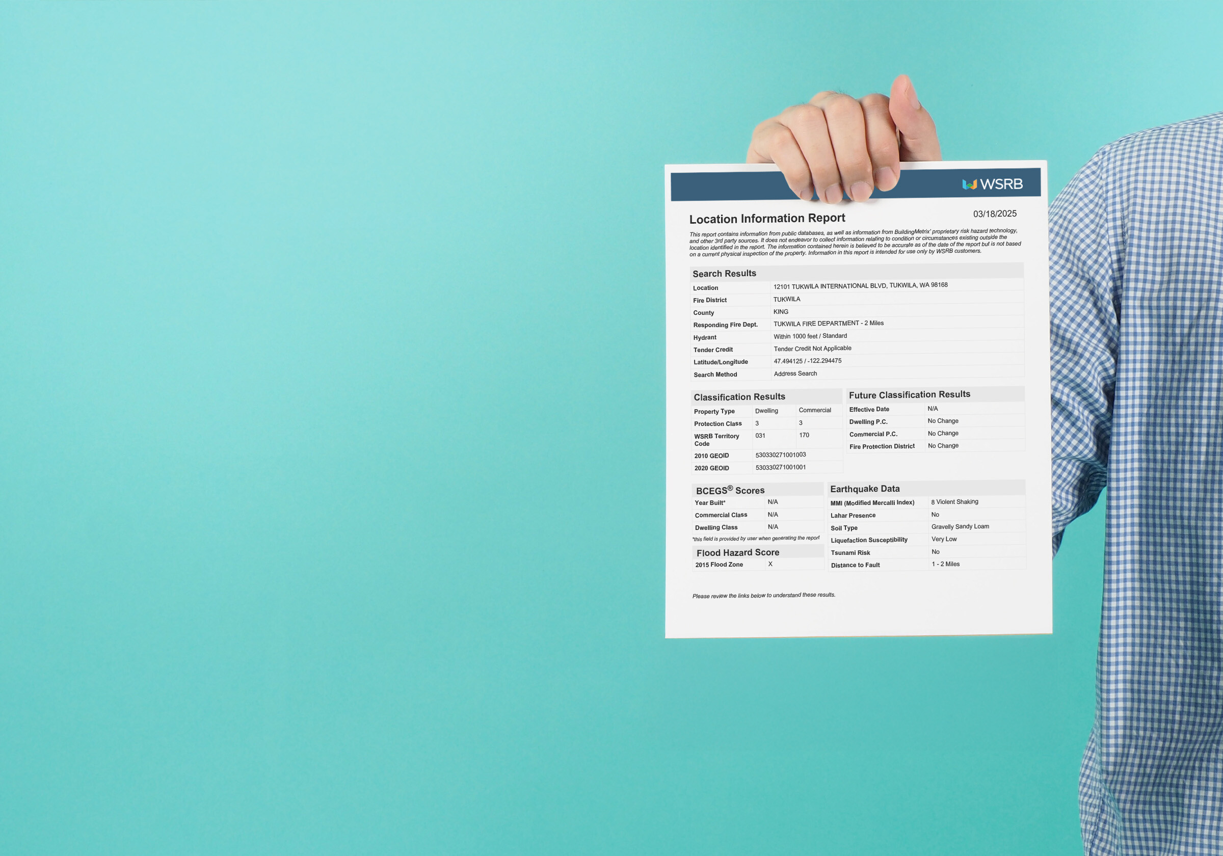
Exciting news for all WSRB subscribers—our new Location Information Report is now live, offering a comprehensive way to access crucial risk and hazard information in a single, easy-to-save PDF.
You can try it out now by selecting the orange PDF Report link in our Protection tool. Click here to learn how to access the report.

What’s included in the Location Information Report?
Here’s a breakdown of the sections included in this report:
Search Results

The report starts by providing key details about the property’s location, emergency services, and geographical coordinates:
- Location: The address matching the one entered in your search.
- Fire District: Fire protection district that serves the property, important for understanding local fire coverage.
- County: The county where the property is located, which can influence certain risk factors like zoning or local building codes.
- Responding Fire Department: Fire department responsible for emergency responses to the property.
- Hydrant Location: Indicates whether the property is within 1,000 feet of a fire hydrant; properties with a fire hydrant nearby may qualify for lower insurance premiums, as faster access to water reduces potential fire damage. Learn how hydrants impact premiums.
- Tender Credit: Whether the community is eligible for tender credit, indicating the availability of mobile water supply for firefighting. This is awarded to communities that have water transportation systems in place for firefighting, even if hydrants are far away. Learn more about tender credit.
- Latitude/Longitude: The geographic coordinates of the property, helping you pinpoint its exact location.
Classification Results

Your property’s fire protection capabilities, which directly influence insurance premiums, are based on WSRB’s Protection Class (PC) ratings. These ratings evaluate fire department quality, water supply, and emergency communication systems. Learn more about protection class here.
Our Location Information Report also includes GEOID information associated with a property, helping insurers enhance risk assessment and verify policy ratings with greater precision. A GEOID is a unique 15-digit identifier from the U.S. Census Bureau that provides granular geographic data, often used as an alternative to traditional rating territories.
BCEGS® (Building Code Effectiveness Grading Schedule)

A score reflecting how well your community enforces building codes, which can affect how buildings withstand disasters like fires or earthquakes. Make sure to enter the BCEGS year to view these results in your report. More on BCEGS here.
Flood Hazard Score

The report uses FEMA Flood Insurance Rate Maps to show if your address is in a designated flood zone. Properties within flood zones may require flood insurance and are at higher risk of flood damage. Find out more about FEMA Flood Zones.
Earthquake Data

Information on seismic risks, including soil type, proximity to faults, and liquefaction susceptibility, is drawn from publicly available datasets. WSRB also calculates a Modified Mercalli Intensity (MMI) score for potential earthquake shaking intensity. Learn more about earthquake data.
Understanding your data from this report
Included in the Location Information Report is a helpful resource page, providing further information on included data and helpful links.
For additional help in interpreting the data, check out these useful links:
How to access the Location Information Report
Getting your hands on the new Location Information Report is simple and intuitive. Here’s how you can access it:
- Log in to WSRB Solutions – Navigate to the Protection tool on the WSRB website.
- Enter the Address – Use the search bar to enter the address of the property you want to analyze.
- Click the Orange PDF Report Link – After your search results load, click on the orange PDF Report link to generate the Location Information Report.
Tip: If you want to include BCEGS scores in your report, be sure to enter the BCEGS year when prompted. - Save – Once generated, you can view, share, and save the report for your records.
For more detailed instructions on utilizing the report, check out this Help Center article.
If you need additional assistance, do not hesitate to reach out to our Customer Service team.


